
ArcGIS: A powerful tool for asset visibility and collaboration in the UPR System
By: Disaster Recovery Coordinators
December 2021
In our previous blog we told you about the UPR Asset Mapping Project and the importance of providing visibility and easy access to the countless assets that the UPR System has. Now, how are we going to do it?
We shared with you in the November issue that the main objectives of our project are to (i) facilitate the identification of resources; (ii) generate a foundation for strategic planning and implementation; (iii) deepen understanding of regional systems and linkages; (iv) catalyze strategic collaborations; and (v) provide a participatory organizing and motivational tool. One of the two main tools we chose to meet these objectives is the geographic information system (“GIS”) platform known as arcGIS by Esri.
First, what is a geographic information system (“GIS”)?
It is software that creates, manages, analyzes and maps all types of data. By connecting data to a map, it integrates location data with all kinds of descriptive information, thus providing a cartographic base and facilitating data analysis. This tool can be used to identify and understand patterns, relationships between assets and their geographic context.
This tool is commonly used to identify problems, manage and respond to events such as those we have experienced in Puerto Rico in recent years (hurricanes, earthquakes, pandemics, etc.), to monitor changes, identify trends, priorities, forecasting, among other things.
How does it work?
Esri’s ArcGIS highlights the four basic elements that make this tool so powerful. We explain them below:
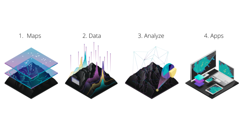
The first component is maps, which serves as the geographic container for the data layers and analyses you want to work with. GIS maps are easily shared and integrated into applications and are accessible to virtually everyone. Secondly, there is the data. GIS software platforms integrate different data in the form of layers of information and anchor them to a spatial location (point on a map). Most data has a geographic component. GIS data includes imagery, features and base maps linked to spreadsheets and tables.
Third, analysis. Spatial analysis allows us to assess suitability and capability, estimate and predict, interpret and understand, among other things, bringing new perspectives to our vision and decision making. Finally, applications provide user experiences that fit the needs, and technological objects (cell phones, computers, tablets, etc.) through which this information is intended to be accessed.
How does access to this platform work?
ArcGIS is a tool that is acquired through licensing. As part of the UPR Asset Mapping project, subsidized by the U.S. Economic Development Administration (“EDA”), the entire UPR System will have access to it. At the moment, we are working hard with the Information Systems team in Central Administration to outline the plan to provide you with access to your ArcGIS accounts and training resources to learn how to use it and get the most out of this amazing tool.
In the meantime!
- We invite you to explore and get familiar with the capabilities of the platform and its online resources available free of charge. We also share with you the following links:
ArcGIS Book Series – https://learn.arcgis.com/en/arcgis-book-series/
ArcGIS Learn – https://learn-arcgis-learngis.hub.arcgis.com/
Esri Training – https://www.esri.com/training/catalog/search/
- Join our team of collaborators!
Do you already know the ArcGIS platform? Do you want to develop more knowledge about its implementation and uses by supporting the UPR Asset Map project?
Fill out this form and join our effort!
Happy Holidays from the DRC Team!